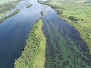
Macrophytes Monitoring System and Solution
China Three Gorges Brasil
Macrophytes Monitoring System and Solution
China Three Gorges Brasil
 Back to Hall of Fame
The Macrophyte Monitoring System
(SMM) is a computational system
based on geotechnology that brought
together extensive environmental and
physical field data as well imagery and
real-time data collected from upstream
hydropower plants and meteorological
buoys installed at the hydropower plant
reservoirs.
The solution is innovative and unique
because it combines floristics,
bathymetry, meteorology, limnology,
hydro sedimentology, open-source
satellite imaging combined with UAVs
and real-time hydrology data into a
single platform to predict the plants’
behavior.
The system’s goal is to support the
hydropower operators who have
operating problems with macrophytes,
aiming for satellite monitoring the
displacement of macrophyte banks and
supporting the development of decision
making and action plan operations
ahead of time to avoid accidents with
aquatic plants, ensuring the continuity
of power generation.
The system is adopted from a geographic
information module that maps the
plants in the reservoir and the average
travel time to the water intake, an alert
module and a detachment trend module
both designed to serve as a functional
tool for everyday use and to indicate
risk situations to operators, and finally
a growth indicators module that allows
the investigation of environmental
parameters that are strongly related to
the growth and displacement of aquatic
plants.

Highlights
- The solution resulting from the R&D undertaken by CTG Brasil and Lactec Institute at Jupia Hydropower Plant in Brazil (a case study), which has been having operational issues with macrophyte plants, demonstrated advances to the current bibliography through the implementation of a fully automated and integrated system.
- The solution is equipped with an alert mechanism whose conceptual model was designed to trigger alerts about events that represent risks to the reservoir through the modeling of flow rate parameters, water quality, meteorology and areas occupied by aquatic macrohytes from the automatic classification of periodic orbital images.
- A processing cycle was developed using machine learning techniques, which provided the best quality classification combined with automation, without requiring user interaction with the machine.
- Its main functionality consists of a modern graphic interface that displays the percentages of occupation by emergent and submerged macrophytes in the reservoir, presented as a function of the passage time of the satellite.
- The system also associates the modeling of bio-optical, hydrological and hydrodynamic parameters, allowing the monitoring of physical and biological conditions for the possible detachment and displacement of these plants, as well as obtaining the reading of the estimated times it takes for their displacement to reach the dam.
View Website
 Back to Hall of Fame
The Macrophyte Monitoring System
(SMM) is a computational system
based on geotechnology that brought
together extensive environmental and
physical field data as well imagery and
real-time data collected from upstream
hydropower plants and meteorological
buoys installed at the hydropower plant
reservoirs.
The solution is innovative and unique
because it combines floristics,
bathymetry, meteorology, limnology,
hydro sedimentology, open-source
satellite imaging combined with UAVs
and real-time hydrology data into a
single platform to predict the plants’
behavior.
The system’s goal is to support the
hydropower operators who have
operating problems with macrophytes,
aiming for satellite monitoring the
displacement of macrophyte banks and
supporting the development of decision
making and action plan operations
ahead of time to avoid accidents with
aquatic plants, ensuring the continuity
of power generation.
The system is adopted from a geographic
information module that maps the
plants in the reservoir and the average
travel time to the water intake, an alert
module and a detachment trend module
both designed to serve as a functional
tool for everyday use and to indicate
risk situations to operators, and finally
a growth indicators module that allows
the investigation of environmental
parameters that are strongly related to
the growth and displacement of aquatic
plants.
Highlights
- The solution resulting from the R&D undertaken by CTG Brasil and Lactec Institute at Jupia Hydropower Plant in Brazil (a case study), which has been having operational issues with macrophyte plants, demonstrated advances to the current bibliography through the implementation of a fully automated and integrated system.
- The solution is equipped with an alert mechanism whose conceptual model was designed to trigger alerts about events that represent risks to the reservoir through the modeling of flow rate parameters, water quality, meteorology and areas occupied by aquatic macrohytes from the automatic classification of periodic orbital images.
- A processing cycle was developed using machine learning techniques, which provided the best quality classification combined with automation, without requiring user interaction with the machine.
- Its main functionality consists of a modern graphic interface that displays the percentages of occupation by emergent and submerged macrophytes in the reservoir, presented as a function of the passage time of the satellite.
- The system also associates the modeling of bio-optical, hydrological and hydrodynamic parameters, allowing the monitoring of physical and biological conditions for the possible detachment and displacement of these plants, as well as obtaining the reading of the estimated times it takes for their displacement to reach the dam.


